34.239.153.44

Aktuelle Messwerte für Mexiko


 Länderauswahl:

Temperatur

20:35 Uhr (Landeszeit) / 02:35 UTC / Zeitzone: UTC-6 bis UTC-8   (Ansicht aktualisieren)

Coban / 1316 mEsquipulas / 965 mGuatemala-La / 1509 mHuehuetenango / 1901 mMelchor De Menco / 105 mPuerto Barrios / 10 mQuezaltenango / 2371 mRetalhuleu / 200 mSan Jose / 9 mZacapa / 490 mCatacamas / 442 mLa Ceiba-Goloso / 15 mLa Esperanza / 1100 mLa Mesa-Pedro S / 26 mNueva Ocotepeque / 2 mRoatan / 5 mSanta Rosa De C / 1079 mTela / 3 mTegucigalpa-Ton / 1004 mTrujillo / 3 mYoro / 670 mTepic / 922 mBelize Intl. / 5 mTallahassee Rgnl / 19 mApalachicola Municipal / 5 mMobile-Bates Field / 63 mMontgomery-Dannelly / 63 mNew Orleans-Intl / 5 mMeridian-Key Field / 89 mJackson / 91 mLake Charles Municipal / 4 mBeaumont-Port Arthu / 5 mHouston-Intnl / 36 mShreveport / 83 mBrownsville Intl. / 7 mCorpus Christi Intl. / 14 mSan Antonio Intl. / 243 mAustin / 166 mVictoria / 31 mWaco / 151 mDallas-Ft Worth / 174 mDel Rio / 313 mSan Angelo-Mathis / 576 mMidland Regional / 874 mAbilene Municipal / 548 mRoswell-Industrial / 1112 mEl Paso Intl. Airport / 1197 mTruth Or Consequenc / 1469 mTucson-Wfo / 752 mSan Diego-Lindberg / 12 mJunction / 522 mEjido Nuevo Leon Bc. / 0 mSan Felipe / 17 mAltar / 419 mNueva Casas Grandes / 1467 mHermosillo Intl. / 184 mTemosachic / 1870 mChihuahua Intl. A / 1372 mPiedras Negras / 250 mSanta Rosalia / 75 mEmpalme / 12 mCiudad Obregon / 43 mChoix / 238 mParral / 1744 mMonclova / 615 mTorreon Airport / 1124 mSaltillo / 1790 mMonterrey / 512 mCiudad Constitucion / 48 mLa Paz / 18 mCuliacan / 39 mDurango Airport / 1857 mMazatlan / 4 mCiudad Victoria / 238 mSoto La Marina / 21 mColotlan / 1673 mZacatecas / 2612 mSan Luis Potosi / 1903 mTamuin, S.L.P. / 0 mTampico-Gen Fj M / 24 mTepic / 922 mAguascalientes / 1863 mGuanajuato / 1999 mRio Verde / 990 mMatlapa / 133 mGuadalajara / 1551 mQueretaro / 1813 mPachuca / 2417 mTulancingo / 2181 mTuxpan / 28 mMerida Intl. Airport / 10 mValladolid / 22 mManzanillo / 3 mCiudad Guzman / 1507 mColima / 723 mZamora / 1562 mMorelia New / 1833 mToluca / 2720 mMexico City / 2308 mTlaxcala / 2248 mPuebla / 2244 mJalapa / 1389 mVeracruz / 16 mCampeche-Ignacio / 5 mFelipe Carrillo / 13 mCuernavaca / 1560 mOrizaba / 1259 mCoatzacoalcos / 34 mVillahermosa / 6 mChetumal / 12 mChetumal, Q. Roo Fam / 0 mChilpancingo / 1360 mHuajuapan De Leon / 1602 mOaxaca-Xoxocotla / 1528 mAcapulco-G. Alva / 3 mSalina Cruz / 6 mArriaga / 44 mTuxtla Gutierrez Airport / 528 mCristobal Las Casas / 2276 mComitan / 1530 mPuerto Angel / 21 mTapachula City / 119 mCabo San Antonio / 8 mBelize Intl. Airport / 5 mSanta Ana-El Palmar / 725 mIlopango-S.Salvador / 616 mSan Miguel-Papalon / 80 mApalachicola / 5 mLaughlin / 330 mDouglas Bisbee / 1265 mFort Stockton / 918 mNew Braunfels / 195 mFort Huachuca / 1438 mMorelia New / 1833 mColima / 723 mTallahassee / 19 mMexico City-Lice / 2238 mNogales / 1184 mToluca-Jose Mari / 2576 mRocksprings / 725 mHebbronville / 202 mPensacola Nas / 9 mPort Lavaca / 9 mMinden / 85 mColumbia-Marion County Airport, Columbia / 81 mBrenham / 94 mBrookhaven / 149 mQuincy / 69 mJennings / 7 mLa Grange / 99 mDefuniak Springs, Defuniak Springs / 88 mS Antonio-Boerne / 423 mDe Quincy Industrial Air Park / 25 mGriffin-Spalding / 292 mCleveland Municipal / 46 mAmericus / 143 mOakdale Allen P / 33 mAlamogordo White / 1279 mAlexander-Russel / 209 mZapata / 129 mLlano / 336 mWharton / 31 mMarshall / 109 mAtlantis Oilp / 62 mArtesia / 1081 mAuburn Opelika A / 236 mHouston-Southwst / 21 mBrady / 557 mBrazos 133B Oilp / 36 mBeeville Municipal / 82 mBainbridge / 43 mBlakely Early C / 65 mBreckenridge / 392 mFalfurrias / 34 mBeaumont / 10 mBig Spring / 784 mBastrop Morehous / 51 mBrazos 451 Oilp / 34 mBrownwood / 423 mBogalusa Carr F / 36 mBay City / 14 mNewnan / 296 mCoulter Field Airport, Bryan / 112 mCasa Granda / 446 mColeman Municipal / 517 mCleburne / 260 mFairhope / 28 mW Cameron 368A / 34 mCastroville Municipal / 235 mCameron, La Gom / 1 mCarrizo Springs Dimmit County Airport / 183 mCrockett / 106 mWest Delta 27A / 36 mDeridder-Fss / 63 mDemopolis Municipal Airport / 34 mHorseshoe Bay / 334 mAndrews / 967 mAlpine-Casparis / 1376 mEdinburg Intl. / 24 mAustin Exec / 189 mE Cameron278Oilp / 31 mEugene I 215 Oilp / 28 mKerrville / 510 mAthens Municipal Airport / 135 mRalph M Hall-Rockwall Municipal / 175 mFort Worth-88D / 208 mMagnolia Oilp / 59 mGranbury Municipal / 237 mGarden Banks172 / 30 mSeminole / 1010 mGatesville / 276 mGreen Canyon 338 / 58 mGunnison 668 / 30 mGreenville-Major / 163 mGalveston424 Oil / 39 mGiddings-Lee / 148 mHammond / 13 mNatchez-Hardy / 83 mAlaminos Canyon / 25 mHobbs-Lea Co. / 1115 mH Island376 Oilp / 26 mHouma Terrebonne / 3 mSan Marcos / 182 mNew Roads / 12 mNatchitoches / 37 mMiss Canyon 474 / 25 mKilleen Municipal / 258 mHillsboro / 209 mIndepedence 920 / 41 mAbbeville Cc Mem / 5 mJasper / 65 mMineola-Quitman / 132 mGulf Shores / 5 mJacksonville / 206 mRaymond / 76 mMidlothian-Wax / 217 mGilmer Municipal / 127 mFallbrook Community Airpark / 216 mLouisiana Rgnl. Airport, Gonzales / 4 mLa Grange / 211 mHearne Municipal / 87 mLancaster / 153 mLas Cruces Intl. / 1358 mLordsburg / 1307 mDecatur / 319 mMexia Limestone County Airport / 166 mLampasas / 371 mHouston-Univ / 69 mMidland Airpark / 854 mMiss Canyon 311A / 31 mMain Pass 140B / 32 mComanche / 423 mHamilton Municipal / 396 mMarfa / 1481 mMustang A85A Oil / 29 mNacogdoches / 108 mOpelousas St Landry Parish Airport And Ahart Field / 23 mN. Padre Island / 25 mThomaston Upson / 243 mOrange / 4 mMount Pleasant / 111 mOzona / 726 mPecos City / 797 mPleasanton Municipal / 132 mPine Belt Rgnl / 91 mPresidio Lely Intl. Airport / 896 mPalestine Municipal / 129 mPatterson Memori / 3 mMc Gregor / 180 mPort Aransas / 2 mHenderson Rusk C / 135 mGraham Municipal / 342 mRuston Regional / 95 mCaldwell / 119 mLago Vista / 376 mMerkel Field Sylacauga Municipal Airport / 173 mS Marsh268 Oilp / 8 mSan Diego-Santee / 117 mCraig Field-Selma / 51 mStephenville / 402 mSulphur Springs / 149 mSnyder-Winston / 741 mSonora / 652 mSouth Padre Island / 4 mShip Shoal178 / 31 mSilver City / 1659 mSweetwater / 727 mGonzales Roger M. Dreyer Memorial / 108 mCameron / 123 mWeslaco Midvally / 21 mFredericksburg / 517 mIngleside-Tp Mcc / 6 mHouston Exec / 51 mTemple-Miller / 208 mUvalde-Garner F / 287 mSulphur / 4 mE Breaks Boomvng / 46 mSabine 13B Oilp / 31 mVicksburg / 32 mViosca Knoll768 / 53 mVermilion 331 / 25 mNew Orleans-Downtown / 9 mBridgeport / 260 mHigh Is. 179A / 75 mPort Fourchon / 2 mDestin / 5 mOceanside-Red-B / 27 mManzanillo Intl. / 8 mHermosillo Intl. / 184 mTyndall / 5 mNorth Island Nas / 8 mSan Diego / 12 mMonterrey Intl. A / 448 mCampeche-Ignacio / 5 mCiudad Juarez In / 1171 mChihuahua Intl. A / 1372 mCiudad Victoria / 238 mSaltillo / 1790 mLoreto / 15 mNuevo Laredo Int / 148 mReynosa Intl. Airport / 39 mTapachula / 29 mCuliacan / 39 mCozumel / 5 mLos Mochis Airport / 4 mChetumal / 12 mMatamoros Intl. / 8 mMazatlan-G. Buel / 10 mTorreon Airport / 1124 mOrange Grove / 78 mSan Antonio / 243 mDel Bajio-Leon / 1819 mPoca Rica-Tajin / 142 mSan Luis Potosi / 1903 mCancun / 10 mAguascalientes / 1863 mMexicali Intl. Airport / 22 mTucson-Ryan Field / 737 mAcapulco-G. Alva / 5 mCiudad Obregon / 43 mGuaymas Intl. Airport / 20 mPuerto Vallarta / 6 mQueretaro / 1813 mVillahermosa / 13 mIxtapa Zihuatane / 6 mLa Paz Intl. Airp / 21 mDallas-Addison / 196 mChandler / 379 mMesquite / 136 mDurango Airport / 1857 mSan Jose Del Cab / 109 mVeracruz / 16 mMarianna / 32 mMiramar Nas-San / 146 mPuebla / 2244 mTijuana Intl. Airport / 152 mHouston-Ellingto / 10 mGrand Prairie / 180 mMerida Intl. Airport / 10 mMonterrey-Gen Ma / 387 mEl Salvador Int / 25 mSanta Ana / 725 mSan Miguel / 80 mIlopango-S.Salv / 616 mWaco / 151 mAustin-Mabry / 201 mAvalon / 482 mBoothville / 1 mCorpus Christi / 14 mColumbus / 135 mEl Paso / 1197 mGuadalupe Pass / 1692 mGeorgetown / 240 mHondo / 282 mJunction / 522 mRoswell / 1112 mSafford / 962 mSan Angelo / 576 mVictoria / 31 mCiudad Del Carm / 2 mGuadalajara / 1528 mAbilene / 548 mCampo / 807 mGalveston / 6 mHarlingen / 10 mFort Worth Nas / 198 mOceanside / 8 mMinatitlan / 40 mOaxaca-Xoxocotla / 1528 mTuxtla Gutierrez / 528 mDryden / 701 mAlbany / 58 mAlexandria / 27 mFt Worth-Allianc / 233 mAlice / 53 mNew Iberia / 18 mSlidell 22 / 9 mAustin / 166 mMobile-Brookley / 20 mBurnet / 389 mBeaumont-Port Airport / 5 mBrownsville / 7 mBaton Rouge / 21 mCrestview / 55 mCollege Station / 96 mCarlsbad / 985 mCotulla / 140 mCarlsbad / 99 mCorsicana / 133 mConroe / 75 mDallas-Love Field / 158 mDallas-Ft Worth / 174 mDothan / 113 mDeming / 1311 mDel Rio / 313 mShreveport-Dwntn / 53 mDenton / 196 mHouston-Dw Hooks / 46 mPanama City / 21 mAlabaster / 173 mEl Dorado / 81 mAlexandria / 28 mPeachtree City / 262 mFort Worth / 214 mLongview / 107 mArlington / 192 mGulfport / 14 mEvergreen / 78 mHattiesburg / 44 mFt Rucker-Hanche / 97 mJackson-Hawkins / 108 mHouston-Hobby / 36 mHouston-Intnl / 36 mWink / 855 mImperial / -17 mAngleton / 6 mLake Charles / 4 mLufkin / 88 mLafayette / 11 mLowe Ahp-Ft. Ruc / 74 mHouston / 12 mMidland / 874 mMccomb / 124 mMcallen / 38 mMontgomery / 63 mMonroe / 29 mNew Orleans-Intl / 5 mMineral Wells / 284 mSan Diego-Mntgmy / 136 mNew Orleans-Lake / 3 mOdessa / 902 mSalt Point / 1 mPort Isabel / 5 mPensacola / 38 mPascagoula / 6 mPalacios / 5 mDallas-Redbird / 203 mRockport / 6 mRamona / 427 mSan Diego-Brown / 159 mHouston-Sugar La / 2 mS Antonio-Stinsn / 176 mTuscaloosa / 49 mTruth Or Conseq. / 1469 mMckinney / 179 mTroy / 118 mTerrell / 145 mTucson / 776 mTallulah-Vicksbu / 26 mTyler / 165 mHuntsville / 104 mFullerton-Polk / 94 mJackson / 91 mCamp Pendleton / 24 mWaco-Tsti / 156 mDuke Field-Eglin / 59 mDimmit / 236 mGray-Ft Hood / 309 mBay St Louis / 7 mNew Orleans Nas / 1 mFort Polk Fr / 101 mEglin-Valpar / 26 mSoto Cano Ab / 626 mAndalusia-Opp Airport / 94 mPioneer Airfield / 1453 mPeason Ridg-Polk / 111 mFort Bliss / 1203 mFt Hood-Killeen / 283 mLaredo / 155 mMcgregor Range / 1283 mMobile-Bates / 63 mMilton-Whiting S / 54 mC. Christi Nas / 6 mEl Centro Naf / -13 mMeridian Nas / 97 mKingsville Nas / 15 mImperial Beach / 7 mWhiting Field Nas / 61 mSan Clemente Is. / 55 mGreenville / 138 mHurlbert / 8 mShreveport / 83 mFt Rucker-Shell / 122 mTampico-Gen Fj M / 24 mSan Nicolas Isla / 154 mYuma Mcas / 65 mFlorala Municipal / 96 mBonifay Tri-Cty / 26 mBarksdale / 51 mBiloxi-Keesler / 10 mDavis-Tucson / 824 mDyess-Abilen / 545 mEufaula / 87 mHolloman / 1248 mHurlburt Field / 12 mFt Benning-Colum / 71 mMeridian-Key Field / 89 mMaxwell-Mgm / 51 mOzark-Cairns / 93 mRandolph / 232 mKelly / 210 mZacatecas Airport / 2177 mCabo San Lucas / 140 mChandler-Mesa / 412 mChenault-Lk Chas / 4 mProgreso / 14 mPensacola / 38 mLa Ceiba-Goloson / 15 mLa Mesa-Pedro Sula / 26 mCatacamas / 442 mTegucigalpa-Toncont / 1004 mTyndall Drone / 5 mVenice Heliport / 1 mBahias De Huatul / 143 mMonclova / 615 mPuerto Escondido / 88 mGeografia Unam D.F. / 0 mUruapan-Gen Rayo / 1593 mLoreto / 15 mLagos De Moreno, Jal. / 0 mSombrerete / 2359 mCuernavaca / 1560 mPalenque International Airport / 61 mAcajutla-Sonson / 15 mChichen Itza Yu / 28 mAcajutla-Sonsonate / 15 mPiedras Negras / 250 mPunta Penasco / 14 m
Aktuelle Messwerte für Mexiko

Hinweis:
• Für weitere Messwerte bitte einen Ort anklicken.
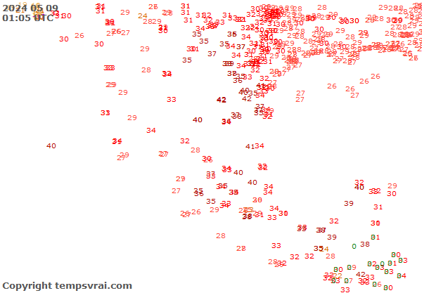

Aktuelle Messwerte für Mexiko

Hinweis:
• Für weitere Messwerte bitte einen Ort anklicken.


Archiv (12 Stunden)


Weitere Wetterelemente
Temperatur [°C]
Taupunkt [°C]
Relative Feuchte [%]
Abs. Feuchte [g/m3]
Bedeckungsgrad [1/8]
Luftdruck [hPa]
Windstärke [km/h]
Böenstärke [km/h]
Windrichtung

Temperatur [°C]
   >= 35
   30 bis 34
   25 bis 29
   20 bis 24
   15 bis 19
   10 bis 14
   5 bis 9
   0 bis 4
   -1 bis -4
   -5 bis -9
   -10 bis -14
   -15 bis -19
   -20 bis -24
   -25 bis -29
   <= -30